
A fleet of robotic floats built and guided by Canadian researchers has produced one of the most comprehensive estimates yet of the ocean’s invisible workforce: phytoplankton. Using a global network of autonomous instruments, the team calculated a biomass of about 314 teragrams—roughly 346 million tons—the equivalent of 250 million elephants hidden beneath the sea’s surface.
A silent census beneath the waves
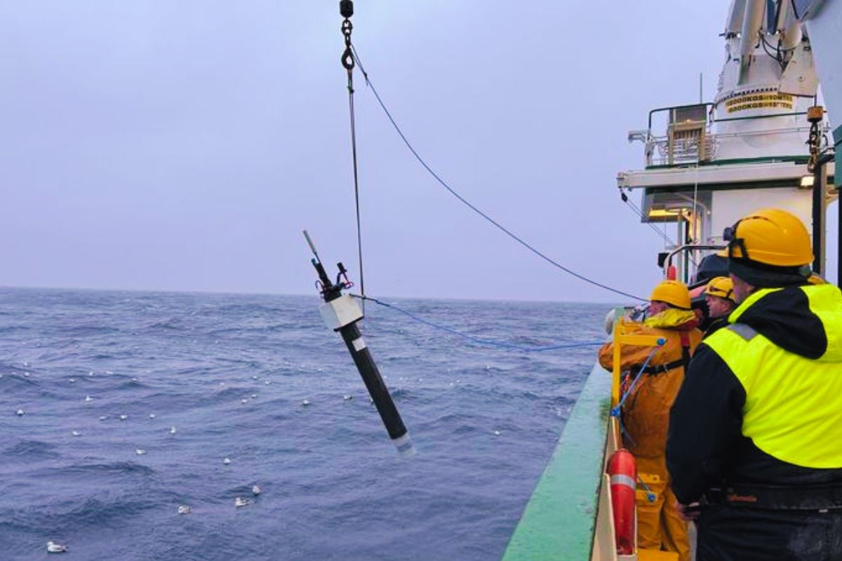
The Biogeochemical-Argo (BGC-Argo) network is a constellation of free-drifting robots that profile the water column from the surface to the deep ocean. Each float measures light, particle backscatter, and other biogeochemical signals that reveal where and how much phytoplankton exists. Over time, the fleet has compiled more than 100,000 vertical profiles, building a dynamic, three-dimensional map of living carbon in the sea.
These autonomous platforms work where satellites cannot: in the murky, light-limited depths and beneath clouds, sea ice, and storms. By resolving biomass through the water column, they capture the “missing” phytoplankton that satellites systematically overlook.
The magnitude of a hidden giant
Phytoplankton are microscopic plants, yet together they form a planetary engine that captures carbon and powers marine food webs. The new estimate—around 314 teragrams of phytoplankton biomass—translates to roughly 346 million tons, or the weight of 250 million elephants. That scale underscores how much life and carbon is sequestered below the sea’s glittering surface.
These organisms generate about half the oxygen we breathe and help moderate the climate by drawing down atmospheric CO2. Their abundance and distribution shape fishery yields, coastal ecosystems, and the long-term balance of ocean chemistry.
Why satellites fall short
Space-based sensors read ocean color, inferring phytoplankton from chlorophyll near the surface. But many blooms occur deep, at the “deep chlorophyll maximum,” where light is dim yet nutrients are available. Satellites also struggle under persistent clouds, sea ice, and in optically complex waters near coasts and river plumes.
BGC-Argo fills these gaps by sampling the full depth, day and night, in clear and turbid seas alike. The result is a more accurate, depth-resolved picture of marine biomass that complements space-based observations.
Key numbers at a glance
- About 314 teragrams of global phytoplankton biomass, roughly 346 million tons.
- Equivalent to the weight of 250 million elephants, spread across the world’s oceans.
- More than 100,000 vertical profiles collected by the BGC-Argo fleet.
- Significant biomass occurs beyond satellite reach, especially at depth and under ice.
A recalibrated perspective for climate science
Accurate biomass estimates improve models of carbon uptake and atmospheric feedbacks. With better constraints, predictions of ocean warming, oxygen loss, and productivity shifts become more reliable. That matters for long-term policy, as nations plan for fisheries, carbon accounting, and ecosystem protection.
This depth-aware view also informs debates about ocean geoengineering, such as iron fertilization proposals that aim to stimulate phytoplankton growth. Without precise baselines and regional variability, interventions can produce unintended consequences for food webs and biogeochemical cycles.
“As we refine our view beneath the surface, we’re discovering a far larger, more dynamic reservoir of living carbon than satellites alone suggested,” noted a lead scientist involved in the analysis. “Any future intervention must be judged against this richer, depth-resolved reality.”
How the robots change the game
Each BGC-Argo float periodically descends and ascends, logging profiles of temperature, salinity, chlorophyll fluorescence, and optical backscatter that correlate with phytoplankton carbon. By stitching these records across basins and seasons, scientists can track phenology—when blooms start, peak, and fade—and how they respond to heatwaves, storms, and shifting currents.
Crucially, the network provides continuity: long-term, standardized measurements that reveal trends rather than snapshots. That continuity is essential for detecting subtle climate signals amid natural variability.
What comes next
The path forward involves expanding the fleet, refining sensor calibrations, and integrating float data with satellite imagery and ship-based surveys. Machine-learning tools will fuse disparate streams into near-real-time maps of global biomass, enabling earlier warnings for harmful algal blooms and ecosystem stress.
As more floats patrol polar and remote regions, the global picture will grow clearer and more actionable. The ultimate goal is a sustained, planetary observatory for ocean health—one that keeps pace with a rapidly changing climate and secures the living foundation of Earth’s biosphere.
The Canadian-led flotation network has shown that the ocean’s smallest drifters collectively weigh as much as a continent of megafauna. With eyes now beneath the waves, science is closer to balancing the books of the planet’s blue carbon, one profile at a time.
🌠🎖🏆🔥
Maybe I’m getting picky but I thought it would be nice to know which ocean we’re talking about. Egads 🙄
They eat carbon and supply our oxygen. THE NARRATIVE, and it’s Father, sigh.
VooDoo Science, More Carbon Dioxide is need in the atmosphere to support life. All life on Earth is Carbon based and requires atmospheric Carbon Dioxide to survive. Removing &/or failing to replace and tncrease the CO2 in the atmosphere will ultimately cause all life on Earth to go Extinct.
Currently only a miniscule 0.04% of atmospheric gas is Carbon Dioxide and it has been proven to have no effect on atmospheric heating.
Let the people who know what they’re talking about talk about the subject. Every step forward you and all the self decided narcissistic “geniuses” take five steps back.
If you will shut up and pay attention like your teacher told you you might just learn something. You don’t have to be a expert to learn or even teach
What does this mean for our oceans and for us. I read the article, but didn’t understand how it fits with the whole picture.
Phytoplankton absorbs CO2 in the ocean like plants do on land. It’s abundance in the ocean will never allow the ocean to become acidic as some people suggest. We are being lied to. As the co2 increases so will the phytoplankton which is the food base for all life in the ocean.
You know we have actual data showing the ocean is becoming more acidic right?
That is a lot like saying “we know the temperature of the oceans.” It’s possible to know the average pH or temperature of the location that was sampled at the time the sample was taken but “the oceans” are a BIG dynamic place and the water is always moving.
Id like to order .00000325 elephants of your finest strip steak please.
🤣
I don’t think there is Canadian ocean just an ocean attached to Canada just like all the other worlds
Oceans.you know pacific/Atlantic…
Says nothing of a Canadian Ocean, Jus that the people who came up with the idea were Canadian I believe. 🇨🇦
Says nothing of a Canadian Ocean, Jus that the people who came up with the idea were Canadian I believe. 🇨🇦
au jus?
The story should be God does not need anyone to take over His perfect job. Stop trying to fix anything that’s not broken or breaking. Try cleaning up something that you understand, not manipulating anything.
Well if everything God made was perfect then explain humans
He has a plan for that also.
I would love to see what this looks like. I’m picturing scenes from Avatar.. flowing smoothly, soft nudging waves… This may sound odd …. But it must be nice to only have one job in your lifetime/lifecycle.. and for them, they are experts at it..
I think these guy are doing something that we should know about with all the talk of global warming and climate change,every other week our world is going to end
So where are elephants 1.83 tons?